


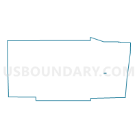
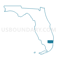
L028-Voting District, Broward County, Florida
About
Outline

Summary
| Unique Area Identifier | 551647 |
| Name | L028-Voting District |
| County | Broward County |
| State | Florida |
| Area (square miles) | 0.21 |
| Land Area (square miles) | 0.21 |
| Water Area (square miles) | 0.00 |
| % of Land Area | 100.00 |
| % of Water Area | 0.00 |
| Latitude of the Internal Point | 26.12845020 |
| Longtitude of the Internal Point | -80.19386280 |
Maps

Graphs
Select a template below for downloading or customizing gragh for L028-Voting District, Broward County, Florida


Neighbors
Neighoring Voting District (by Name) Neighboring Voting District on the Map
- L027-Voting District, Broward County, FL
- L029-Voting District, Broward County, FL
- N001-Voting District, Broward County, FL
- Z034-Voting District, Broward County, FL
Top 10 Neighboring County Subdivision (by Population) Neighboring County Subdivision on the Map
Top 10 Neighboring Place (by Population) Neighboring Place on the Map
- Plantation city, FL (84,955)
- Lauderhill city, FL (66,887)
- Washington Park CDP, FL (1,672)
- Boulevard Gardens CDP, FL (1,274)